Locating London's past: a geo-referencing tool for mapping historical and archaeological evidence, 1660-1800
Locating London´s Past has created an intuitive GIS interface that enables researchers to map and visualize textual and artefactual data relating to seventeenth and eighteenth-century London against a fully rasterised version of John Rocque´s 1746 map of London and the first accurate modern OS map (1869-80). More than this, it makes these data and maps available within a Google Maps container, allowing for the analysis of the data with open source visualization tools. The interface is readily expandable to include additional data sets and maps (both modern and historic).
Building on the partnerships created through the JISC funded Connected Histories project, and through a new collaboration with the Museum of London Archaeological Service (MOLA), Locating London´s Past has produced a working GIS-enabled public web environment that allows existing electronic historical data about London to be repackaged and organised around space.
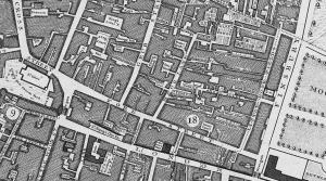
The project incorporates four elements. First, a fully rasterised and GIS-enabled version of John Rocque´s 1746 map of London has been created and tied to a GIS enabled version of the first reliable modern OS map (1869-80). Second, standard geo-referencing has been incorporated into some 4.9 million lines of data drawn from the Old Bailey Online, London Lives, 1690-1800, datasets created by the Centre for Metropolitan History, and MOLA´s extensive database of archaeological finds. Third, using an API methodology, the historical GIS has been presented for public use and re-use both online and as downloads, within a Google Maps `container´ (giving access to satellite images, `street views´ etc), to facilitate `mash-ups´ with modern datasets (geological, flooding, land use, etc). This in turn creates an environment in which additional external historical datasets and GIS enabled historical maps can be added. Fourth, a series of open source visualization tools, with examples and documentation, has been made available through the interface to allow datasets with multiple variables about crime, social policy, taxation and material culture to be represented and analysed in conjunction with the three layers of GIS-enabled mapping (Rocque, OS, Google Maps).
By bringing within a single framework archaeological evidence of pipes and shards, and historical trial records, voting lists, insurance files and taxations records, this project contributes to the `spatial turn´ in humanities and social science scholarship, not just by making geographical analysis possible, but by making it readily accessible.
Read more about the project's progress in the Locating London's Past blog.
The mapping resource is now available at: www.locatinglondon.org
Interview with Professor Robert Shoemaker on the Today programme (BBC Radio 4, 12 December)
Article by Professor Matthew Davies in Past and Future (Spring/Summer 2012)
Winner of the 2014 BSECS Prize for Digital Resources: 'This is a superb new free resource, which applies the latest digital mapping techniques to the study of London. It brings together a range of existing datasets, which are particularly useful for the study of "history from below" - but which will also be of tremendous interest to the full range of disciplines that work on the eighteenth century, including literature, politics, theatre and music, to name but a few. The panel were impressed with the technical advancements represented by the site, but also with how easy it is to use. By making issues of urban space and historical geography so accessible, it promises to change the way that we approach the study of the capital in the eighteenth century.'
Project details
Principal investigators: Professor Robert Shoemaker (University of Sheffield), Professor Tim Hitchcock (University of Hertfordshire), Professor Matthew Davies (CMH)
Project Manager: Sharon Howard (University of Sheffield)
Technical Officer: Jamie McLaughlin (HRI Digital)
Funded by: JISC e-Content Programme 2011: Enriching via Collaboration (1 March 2011-30 September 2011)