
Epidemics and the Built Environment in 1665
Justin Champion
Part of the online series Epidemic Disease in London published by the Centre for Metropolitan History
Epidemic Disease in London ed. J.A.I. Champion (Centre for Metropolitan History Working Papers Series, No.1, 1993): pp. 35-52 (© Justin Champion, 1993)
[The causes of the plague were] thicknes of inhabitants; those living as many families in a house; living in cellars; want of fitting accommodations, as good fires, good dyett, washing, want of good conveyances of filth; standing and stinking waters; dung hills, excrements, dead bodies lying unburied and putrefying; churchyards too full crammed; unseasonable weather ...William Boghurst, Loimographia (1665)
Writing in 1662 in his Natural Observations, John Graunt was convinced that there was a precise 'physico-mathematical' relationship between (as he put it) the 'waxing and waning of diseases' and the quality of the built environment. The 'turning of great palacious houses in to small tenements' and the consequent increasing density of the population led to an increased rate of mortality: as the parochial areas of London grew 'madly disproportionate' so did the patterns of death. (1) The College of Physicians, considering the factors that promoted urban disease in the early 1630s, had argued that the expansion of poor quality residential building attracted poor inmates and lodgers - 'by whom the houses are so pestered that they become unwholesome'. (2) In July 1665, when the plague epidemic had become visible to London society, Roger L'Estrange commented that the heaviest impact was felt by the poor 'who are either crowded up into corners, and smothered for want of aire; or are otherwise lost for want of seasonable attendance's and remedies. Nay too often perchance for want of bread, which is no wonder in several of the out parishes that are very popular, and whence the rich have withdrawn themselves'. (3) It was then a common assumption of early modern writers that there was a causal connection between the quality of the built environment and the differential pattern of mortality. This commonplace early modern conceptual bracketing of dirt, poverty and disease has formed the basis of much modern historical writing. This paper, based on the research fundings of one part of the Centre for Metropolitan History (CMH) project 'Epidemics and Mortality in the pre-Industrial City' (4) which examined the epidemic of 1665 in London, will survey some of the approaches that can be employed to explore the social topography of disease in metropolitan spaces. (5)
The first point to make concerns sources, methods and techniques. There are a number of ways in which the relationships between mortality and human environment can be explored and understood. One specific form of enquiry might explore the material connection between the location of death and the quality of the urban environment (as for example reflected in the size or value of the housing). Other approaches might focus upon spatial differentiation: understanding the variations between distinct localities within the city by calculating an overview of patterns of death in a city-wide or local context. Yet another tactic might pose questions in terms of the seasonality of such relationships between wealth and disease. So the simple sorts of questions to pose are for example, what parts of the city suffered the biggest mortality crises and at what time of the year? How did the disease move around a local area? What type of households suffered at particular points in time?
In order to accomplish these historical objectives at least three variables are necessary: one to describe the patterns of death, another to quantify the quality of the housing conditions, and a third, some form of contemporary cartographic material upon which it would be possible to map the other variables. Early modern London is well provided for in terms of the first and third categories: data about the patterns of death for the entire metropolitan area survive in two distinct forms. First, the Bills of Mortality (Fig. 1) provide an aggregate figure for deaths week by week and annually for the second half of the seventeenth century: similarly they provide some elementary diagnosis of the cause of deaths, in particular noting the number of deaths attributed to plague in each parish. (6) Supplementing the bald figures of the Bills are the many manuscript burial registers, which although variable in quality and survival rate can provide important data about the age, gender, status, occupation and location of the dead within individual parishes. (7) Contemporary topographical surveys and maps of London survive in many forms ranging from very detailed literary sources like John Stow's famous Survey of London (1598), or William Faithorne's map of 1658 to the more detailed cartography of Ogilby and Morgan in the 1670s and 1680s, and John Rocque in the eighteenth century. (8)
Fig. 1. 'The annual Bill of Mortality for London and its environs, 1665'
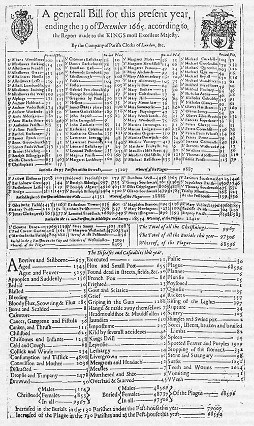
Click here for a full page version of the above (large file size: 1 megabyte)
To explore, then, the relationship between disease and environment is a fairly straightforward procedure given the various computer software packages now available. (9) Using some of the lay-friendly relational database programmes it is possible to relate deaths to places. Trying to characterize the quality of housing, or the social structure for a particular parish in the city in any historically significant manner is rather more complicated.
Although there are many qualitative references to the squalor or luxury of contemporary housing conditions, finding a source that expands such literary comment into a variable that might be applied with some accuracy across the whole city and for every household is less straightforward. Taxation records that focus upon the value of property, in one way or another, provide a particularly good form of data that can be used to map housing conditions across the city. As the important work of Michael Power has shown, the Hearth Taxes of the Restoration which record the number of fire hearths per taxable household give a uniform factor with which to compare the experiences of different areas of London. (10) Before going on to discuss some of the patterns of mortality and social structure revealed by mapping hearth tax data with the Bills of Mortality it is worth just briefly considering the relationship between taking the number of hearths in a household as a measure of the quality of that housing and the 'real' living conditions in such quarters.
Research into the historical reconstructions of physical house size - that is studies that have explored the numbers of, the sizes of, and even the contents of rooms - have enabled early modern historians to come to some general assessment and understanding of the dimensions of wealth and poverty in the early modern city. (11) For example, it seems a fair historical assumption that households that had only one or two hearths can be characterized as poor. (12) Supplementing this type of economic understanding it would be possible to contrive an historical investigation based upon a variety of other types of surviving sources. For example studies of archaeological material might be combined with examinations of probate inventories to expose the physical and material structure of the early modern house. (13)
A different, but essentially complementary, approach might pursue other types of record that were concerned with the social management of poverty, illness and disease. Such sources might include Churchwardens' account books, records of the overseers of the poor, or listings of alms distributions which might, for example, give ample evidence of the number of households needing parish relief. Another source might be found in the quarter sessions and other records that list landlords prosecuted for sub-dividing houses for rent to lodgers, inmates and migrants. Again, from this type of combination of sources it is possible to build up a picture of what types of household (conceived in a strictly economic, social or material manner) were considered by contemporaries as marginal. From this sort of confluence of sources that focus upon the household it seems uncontentious to argue that ownership of hearths in some respects not only signified the physical quality of the living space but also related to the socio-economic position of the resident household. How the historian can relate these general characteristics of social and material environment to the impact of plague in 1665 is worth considering next. In order to do so in some detail I will refer specifically to the CMH project.
Table 1
Relating deaths to number of hearths per household
| Parish | Size of house in number of hearths | |||||||
|---|---|---|---|---|---|---|---|---|
| 1 | 2 | 3 | 4 | 5 | 6 | 7 | 8+ | |
| St James Clerkenwell (44) | 31.7 | 20.8 | 24.7 | 9.7 | 2.6 | 3.2 | 1.2 | 6.2 |
| | 39.8 | 19.3 | 16.7 | 7.3 | 3.9 | 2.7 | 1.9 | 8.4 |
| St Botolph without Aldgate (41) | 31.2 | 25.2 | 22.3 | 8.3 | 4.7 | 4.7 | 1.5 | 2.2 |
| | 26.5 | 33.1 | 24.4 | 5.1 | 3.8 | 4.1 | 1.5 | 1.7 |
| St Dunstan in the West (49) | 15.5 | 11.7 | 12.6 | 20.2 | 8.6 | 5.0 | 4.7 | 21.7 |
| | 10.7 | 7.5 | 7.3 | 14.3 | 11.9 | 10.5 | 8.7 | 29.1 |
| St Michael Queenhithe (20) | 35.1 | 24.3 | 16.2 | 5.4 | 5.4 | 2.7 | 2.7 | 8.1 |
| | 24.3 | 12.9 | 20.0 | 7.1 | 15.0 | 10.0 | 2.1 | 8.5 |
| St Saviour Southwark (42) | 14.2 | 31.8 | 28.2 | 12.4 | 6.9 | 4.3 | 0.7 | 1.5 |
| | 30.0 | 33.5 | 20.1 | 7.5 | 3.8 | 2.9 | 0.9 | 1.3 |
Source: CMH database compiled from Hearth Tax Returns, 1662-1666. Figures in parentheses are the percentages of deaths linked to households recorded in the Hearth Tax. The top line contains the percentages, for each house size, of all deaths linked to households recorded in the Hearth Tax. The emboldened figures are the percentages, for each house size, of the total number of households assessed. |
||||||||
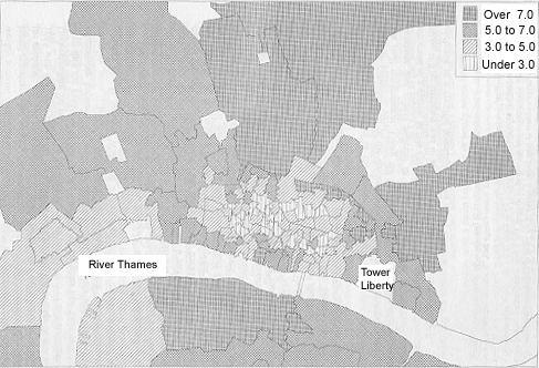
Using the Hearth Taxes of the 1660s it is possible to describe the structure of household wealth of most of the parishes of metropolitan London. (14) So, for example, it is possible to compare mean size of houses in terms of hearths, the number of rich and poor households, the ranges of house sizes, and the density of housing, with a profile of the population that died derived either from the general weekly account contained in the Bills of Mortality or specifically from individual burial registers. One simple, but important, exercise might correlate the size of the epidemic crisis in each parish (calculated by dividing the number of deaths in 1665 with the mean figure for the previous decade) with the average hearth size. Understanding the process of the epidemic from the position of this static annual snap-shot the evidence of the project (see Fig. 2) suggests that there is a clear relationship between the poor populous suburban parishes and a high crisis mortality ratio (CMR): as Paul Slack has pointed out the wealthy intramural parishes like St Stephen Walbrook experienced minimal crises compared with parishes such as St Botolph without Aldgate.
The plague then, as contemporaries surmised, was a morbus pauporum. A further exercise enables us to map the epidemiological progress of the plague in 1665. By digitizing a map of London and its environs and then feeding in the data drawn from the Bills it is possible to reconstruct a picture of how the disease moved through the city, suburbs and out parishes, tracking when the plague hit each parish. In this way it is also possible to pinpoint exactly when different parishes experienced the worst of the epidemic, and indeed to compare the epidemic experience with the endemic. Such exercises illustrate, among other things, that while there was a broad relationship between suburban poverty and high epidemic mortality, the wealthy west end and intramural parishes did not escape quite severe death rates (see Fig. 2). The result of such computer-assisted global examinations of the experience of London as an aggregation of diverse parishes seems then to echo the findings of Graham Twigg: that the poorer parishes acted as a reservoir of the disease, but that the middling and wealthy areas were not immune from increased infection. The connection between environment and mortality was more complex than the immediate picture suggests.
Fig. 2. Crisis mortality ratios for London and its environs, 1665
(Source: Bills of Mortality 1655-65)
Exploring the impact of the plague in a single parish will allow a more detailed consideration of the epidemiological relationship between disease and the built environment. Using the available software it is possible to create a database that relates material in burial registers with the precise household structure of a parish, in this case the wealthy west-end area of St Dunstan in the West. (15) The intention was to attribute each identifiable death during the plague outbreak to a specific household in an exact location within the parish: in this way the link between household structure and epidemic mortality could be established with some measure of precision.
The parochial area of St Dunstan covers, not only the ecclesiastical parish, but also the liberty of the Rolls and the precinct of Whitefriars. Topographically, the area was dominated by Fleet Street, described by a contemporary as, 'a great thoroughfare for coaches, carts, horse and foot passengers; being the great way from London to Westminster'. Fleet Street contained traders and services of all sorts, being well inhabited 'by shopkeepers of the best trades; as woolendrapers, linendrapers, grocers, saddlers, upholsterers [and] booksellers'. Trade in the street was 'very considerate'. The other dominant street was Chancery Lane, being notable for the prevalence of legal accommodation such as Symmonds Inn, Cliffords Inn, and Sergeants Inn. Indeed it was the inns of court and the attendant people that flocked there, lived and worked there, that determined much of the social and economic character of the parish. Supplying the legal profession with accommodation, entertainment, and food and drink, meant that the area was replete with taverns, eating houses, inns and coffee-houses. For example the Bolt and Tun Inn, off Fleet Street near the entrance to Whitefriars, was said to be a great resort 'for coaches and horses, especially in term time'. Bonds Stables, accessible from both Fetter Lane and Chancery Lane, was a large yard dominated by the inn and much frequented by lawyers and their clients. As the Wardmote Inquests illustrate, the base of the occupational structure of the parish was dominated by victuallers (licensed and unlicensed), vintners, innholders, alehouse keepers and cooks. For example, in December 1664, there were seventy names linked with the food and drink industry, excluding grocers, bakers and other retail businesses. (16) Such activities would also have associated with them a high proportion of servants and marginal workers such as laundry maids, servants, porters and carriers attached to the taverns, hostelries and coffee-houses. A long Fleet Street there were fruiterers, tobacconists, apothecaries, milliners, gunsmiths, and gold and silversmiths. Fetter Lane held shoemakers, a smith, cutlers, a matchmaker, a printer, as well as the usual array of bakers, butchers, cooks and grocers. Tucked away in the yards and alleys were chandlers, sandwich men, glaziers, and tobacco pipe makers. (17) St Dunstan in the West was then, on the face of it, a thriving, successful and even affluent parish.
Indeed this broad impression is justifiable if not entirely accurate. An analysis of the taxation material shows that although St Dunstan's was one of the most wealthy parts of London, with a mean house size of nearly seven hearths, it was an area that followed the classic social topography of the early modern city as described by historians like Michael Power. Annexed to the wealthy locations around Fleet Street and Chancery Lane were the more middling district of the Rolls Liberty, and the poor and seedy alleys of the riverside precinct of Whitefriars. St Dunstan, then, encompassed the extremes of wealth and poverty (see Fig. 3). Behind the large main streets and courtyards where eminent politicians like Sir Bulstrode Whitelocke, or the irreligious traveller Sir Henry Blount, had their city residences, there was a labyrinth of alleys and yards. Places like Three Legg Alley, off Fetter Lane, were described as 'of very small repute, being but meanly inhabited'. Or Hercules Pillars Alley, off Fleet Street, as 'but narrow, and altogether inhabited by such as keep public houses for entertainment'. If the general character of the parish was known in polite society for its connections with the law, back streets like Ram and Whites Alley, or Whitefriars, were infamous for being overcrowded with 'disabled and loose kinds of lodgers', and with lewd houses, debtors, vagabonds and 'unbridled lawlessness'. While Two Crane Court might be described as 'a very handsome open place ... graced with good buildings, well inhabited by persons of repute', quarters like Cock and Key Alley and Whitefriars had become, during the course of the early seventeenth century, congested with divided tenements and multiple occupancies. For example, in the 1620s one Francis Pike a victualler had subdivided his property into 39 separate rooms. (18)
Fig. 3. Distribution of hearths in the parish and associated liberties of St Dunstan in the West, 1662-66
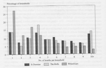
Examining the database created from the surviving taxation records of the 1660s enables us to gain a more precise taxonomy of the hierarchy of household wealth and poverty. (19) For the entire area there were some 96 8 houses at a mean size of 5.8 hearths. If this figure is broken down into the different sectors, St Dunstan's parish shows the highest value at 6.8, with the Rolls Liberty at 6.1 and Whitefriars the lowest at 4.0. The evidence of Figure 3 illustrates the differences and inequalities of housing quality in the various areas. While it is clear that the parish area of St Dunstan remained the wealthiest area with a fairly even distribution of houses above four hearths - suggesting that while there was a proportion of poor housing (perhaps 20 per cent) the vast majority of houses were above or around the mean for the whole area - Whitefriars and the Rolls Liberty show a different pattern. Whitefriars shows an imbalance of distribution weighted towards the poorer quality of housing - 27 per cent at only one hearth, and only 4 per cent above ten hearths - and over 70 per cent of the households fall below the overall mean. The Rolls, significantly, shows a different imbalance - a high percentage below the average, mirrored by a high percentage above it - reflecting perhaps the number of large legal residences and the proliferation of small service shops and cook houses to support them. An examination of these patterns of hearth distribution in even greater detail at the level of the ranges of ownership at the street and alley level shows that the inequalities of housing persisted not only between different areas of St Dunstan but even within the same streets. Chancery Lane showed a preponderance of large houses, while Whites Alley, Sheere Lane and Cock and Key Alley were dominated by smaller scale buildings. Thoroughfares like Fleet Street and Fetter Lane, while having significant numbers in both the poor and substantial categories, had the bulk of their properties above and around the mean range.
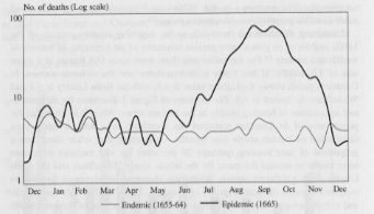
Importantly, these different areas showed distinct seasonal patterns of death. Using the Bills of Mortality for the decade before 1665 it is possible to indicate the endemic pattern of mortality for the entire area during the course of a year,fluctuating from a low of two deaths per week to a maximum of seven. The moving average displays a typical seasonality of death for the early modern period, with peaks of deaths in the late summer and winter months and a relatively stable period from April to late August. Between 1655 and 1664 on average there were about nine deaths every fortnight. The data for 1665, as expected in an epidemic year, shows a very different pattern. In total 939 people died between January and December, 670 of them attributed t o the plague. So about four times as many people died in 1665 compared with the average: that is about nine people every three days rather than every fortnight. At the height of the epidemic (the third week of September, 19-26th) 82 people died (see Fig. 4) .
Fig. 4. Seasonal patterns of mortality for St Dunstan in the West, 1655-64 and 1665
(Source: Bills of Mortality 1655-65)
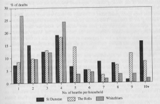
Concentrating upon the epidemic period from mid-July to the end of October the imbalanced distribution of death hit the poorer areas of Whitefriars and The Rolls much harder than the more affluent St Dunstan: over three times as many people died in the Rolls and Whitefriars as in the parochial precincts of St Dunstan. When the people who died are related to household structure it is clear that the epidemic was not spread evenly over houses of different wealth. In all of the three sub-districts death s were clustered in below average hearth sizes: in Whitefriars where the average hearth size was 3.3 compared with 6.6 for St Dunstan, over 34 per cent of the deaths occurred in households with only one hearth (see Fig. 5). If mortality by street or alley is examined it becomes apparent that places that indicated an imbalance towards smaller and poorer properties like Whites Alley, Fetter Lane and Cock and Key Alley all exhibit a high proportion of plague mortality. Evidence from the other parochial areas subjected to the same analysis suggests a similar pattern; that in general mortality broadly followed the social structure, but with a disproportionate burden falling upon the poorer households, indeed in many cases where larger houses were struck with the disease it was the servants rather than the householder that died.
Fig. 5. Deaths linked to number of hearths per household in St Dunstan in the West, 1665
The final type of exercise that can be undertaken is the detailed reconstruction of the impact of the epidemic in a specific street or alley. Importantly with this type of micro-study it is often possible to use more qualitative types of record such as churchwardens accounts and vestry minutes, to delineate how the parish responded to the needs of the infected. (20) The civic response to the epidemic was to 'shut up' the sick poor: this may very well have affected patterns of mortality amongst the poor, since it was they that suffered the highest rates of mortality. (21) Supplementary detail on the social status of those who died can be gleaned from the accounts of parish expenditure issued by Henry Dorsett, Churchwarden of St Dunstan. Under the rubric of the Jacobean statute of 1603, each parish was enabled to raise and distribute money to the poor, as the law read, 'who of necessity must be by some charitable course provided for, lest they should wonder abroad and thereby infect others'. St Dunstan's Vestry was highly organized in its response to the epidemic. By June they had, according to the instructions of the Book of Orders, appointed watchers for the parish: Thomas Welham was to survey Whitefriars for the disease, and Francis Cooper (a man who had been given parish relief in February of 1665) was now given the job of 'watching' for St Dunstan. Two female 'pentioners', Widows Briggs and Manton, were appointed searchers and paid two shillings a week for their duties of inspecting plague-ridden corpses. On the 3rd of July the Vestry ordered the Churchwarden to make a list of payments to the poor. It is this list that provides a valuable source for tracing the impact of the disease on the poorer members of the parish. (22)
The main types of expenditure that Dorsett distributed fell into four broad categories: he either paid individuals or families relief, for necessary supplies or nursing services for infected households, for the 'watchmen' to keep an eye on the infected households, or for miscellaneous services like grave digging, setting on padlocks, or carrying away corpses. The bulk of the payments were made to inhabitants of the poor localities like Whitefriars and the back alleys and yards. The experience of the inhabitants in Cock and Key Alley is a good example: as noted above the alley was a place of ill repute, tucked away between Fleet Street and Whitefriars, and it commonly attracted the attentions of the parish constables. It contained some 20 houses and at least 24 households, the bulk of which contained only about 2 hearths; many of these households took in lodgers and inmates. During 1665 there were 36 deaths, 23 of which were attributed to plague. Eleven out of the 12 households that were infected were shut up by the churchwardens and constable. (23) When the pattern of disease is represented household by household it is apparent that the smallest houses even in this poor area suffered the disease in a more concentrated manner than elsewhere. For example, in the single hearth house of Widow Rebecca Anderson, licensed victualler, there were three deaths including her own. Ann Gurney, another victualler, saw her husband and daughter die in early August. The clustering of multiple deaths in such small houses is very different from the experience of the large houses upon Fleet Street or Chancery Lane where the deaths that occurred were singular.
So what can be said in general about the relationship between mortality and the built environment in the Great Plague of 1665? There seems to be one general theme that all three approaches outlined in this paper confirm. The metropolitan examination, the parish study, and the street or alley reconstruction all point to a general argument that the standard of environmental living, as reflected in the type of physical space inhabited, determined the type of mortality experienced. If you lived in Cock and Key Alley rather than Chancery Lane, or in St Botolph without Aldgate rather than St Mary Colechurch you were more likely to contract the plague. This did not mean that living in the wealthier places conferred an immunity upon any household. Does this pattern then tell us anything about the disease itself?
That poverty breeds disease is the commonplace assumption underlying this suggestion. Indeed the biomedical diagnosis would reinforce this case by suggesting that poverty breeds rats and fleas which caused the epidemiological factors that provoked the outbreak and shape of the plague epidemic. (24) However it seems certain that one result of mapping the progress of the disease throughout the metropolitan area is an epidemiological model that militates against the traditional explanation of the Great Plague as borne by the rat flea mode of transmission.
The pattern of infection between intra- and extramural parishes, and north and south of the river does not conform to the logic of the vectors implicit in the epidemiological theory of Yersinia pestis. Recently Paul Slack has written that in trying to understand the etiology and impact of the disease we ought to be clear about distinguishing between the role of environmental and human causes in determining patterns of mortality in the plague epidemics. So, for example, how much did the civic public health policy of policing the public environment by shutting up the sick and diseased in their habitations contribute to the experience of death in poor communities? Simply to invoke the ubiquitous but unidentified rat as the determining quantity seems historically short-sighted: it also implies a very static model of the social processes that created the patterns of urban health and disease.
Let me give one last example that might illustrate this point: one result of research into the profile of the populations which died in 1665 has been the discovery that there was a significant gender bias towards women as victims of increased mortality rates. (25) On average more men than women died in London between 1655 and 1664. Of the background pattern for the decade before the epidemic 52.3 per cent of those who died were men: or for every hundred males that died only about 90 females followed them. During the plague, however, this pattern altered quite radically. Taking the whole year into account deaths attributed to females increased from the background pattern by 6.6 times compared with male mortality that rose by a factor of 5.8. There was in effect a shift in the distribution of deaths of about 3 per cent: that is, for every 100 female victims there were about 99 male deaths.
This alteration of mortality levels in terms of gender is even more apparent when considered over the course of the year. As with the different patterns of death displayed in the various parishes, it appears that male and female experienced a different seasonal mortality. The background seasonal pattern shows female deaths following the same general distribution as male deaths but at a lower rate: there was a coincidence of peaks in winter and spring. At one point only, mid July, does female mortality supersede male (Fig. 6). In 1665 there was a different pattern. Up until August, compared with the background experience, women suffered more than men: so even before late June or early July, when the epidemic was diffused throughout the City and environs the mortality ratio between men and women was narrowing. If the magnitude of the crisis year is compared directly with the endemic seasonality it is clear that from late July, August and September the rate of female deaths became worse (see Fig. 7). By late summer London experienced a crisis 21 to 24 times worse than the mean experience, illustrated in the graph by the double peak: the first peak in CMR hid a difference between male and female rates of 25.4 compared with 28.3; the second, a mortality gap of 24.7 compared with 30.0. As a simple process then, it seems that the high points of the plague crisis were driven by a profound deterioration in female health that persisted to the end of the year. As Figures 6 and 7 illustrate, the commonplace pattern of more male deaths was reversed during 1665: at the crisis point between two and five times more women were dying than would be habitually expected. When this trend is examined against the data relating to hearth size and topography it seems clear that although the material environment set the necessary preconditions for crisis mortality, the sociological ramifications of civic policy may give a better account for more women dying than men. (26)
Fig. 6. Gender ratio of burials in endemic and epidemic years for London and its environs
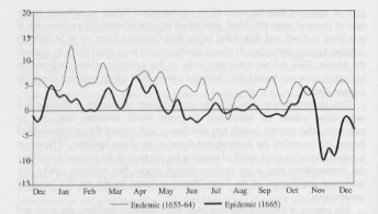
Source: Bills of Mortality 1655-65. The series for 1655-64 and
1665 were calculated by subtracting weekly female burials from male
burials and expressing the result as a percentage of total burials
for each week. Positive values represent more male than female burials,
negative values indicate the reverse.
Fig. 7. Crisis mortality ratios for London and its environs, 1665
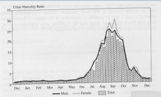
CMR was calculated by division of the
weekly number of deaths for 1665 by a mortality mean derived from
the Bills, 1655-1664.
Thinking about the possible social explanation for the incidence of increased female mortality raises some interesting questions about how historians have approached the interreaction between disease and society. It may now be incumbant upon historians to try to develop a model of the relationship between disease, social structure and material life that encompasses social and civic processes as well as biological. One place to start 'rethinking' the problems of disease and society in early modern England would be to consider, for examples the models constructed by Arthur Marwick in his consideration of the 'impact' of war on British society in the early twentieth century. Extrapolating from Marwick's work it may be possible to understand of the impact of disease upon society in far more dynamic terms than the traditional static assumptions about the causal relationship between poverty, dirt and illness. (27)
Related Publication:
J.A.I. Champion, London's Dreaded Visitation: The Social Geography of the Great Plague
Notes
- John Graunt, Natural and political observations made upon the Bills of Mortality, in Charles Henry Hull (ed.), The economic writings of Sir William Petty, vol. 2 (1899), pp. 321, 370, 379. Back to 1
- Historical Manuscripts Commission Eighth Report (1881), p. 228. Back to 2
- The Intelligencer, 21 July 1665. Back to 3
- This two-year project, conceived by Dr Derek Keene and Dr John Henderson, consisted of two separate but related studies, one funded by the Economic and Social Research Council (concerning Florence and London; Ref. No. R000231192) and the other funded by the Wellcome Trust ('The social geography of plague in seventeenth-century London'). Back to 4
- For an interesting overview, see Gerard Kearns, 'Zivilis or Hygaeia: urban public health and the epidemiologic transition', in Richard Lawton (ed.), The rise and fall of the great cities (1989). Back to 5
- For a general account of the Bills of Mortality: see Graunt, Natural observations; C. Walford, 'Early Bills of Mortality', Transactions of the Royal Historical Society, 7 (1878); discussions of how the Bills were created can be found in J. Christie (ed.), Some account of the Parish Clerks (1893). Dr Paul Laxton is preparing a complete edition of the surviving Bills for publication on microfilm. For a more specific account of the role of women in compiling t he Bills, see Thomas Rogers Forbes, 'The Searchers', Bulletin of the New York Academy of Medicine, 2nd series, 50 (1974). Back to 6
- For those studying disease in London most of the surviving registers for the metropolitan area can be consulted in the Guildhall Library. The Library's Handlist of Parish Registers, Part One: Registers of Church of England parishes, and other sources material relating to Anglican baptisms, marriages and burials, within the City of London is an essential source. Part Two covers parishes outside the City. For an interesting dicussion of the relationship between the registers and the printed sources, see Ian Sutherland, 'Parish Registers and the London Bills of Mortality', Journal of the Society of Archivists, 4 (1970), p. 65. Back to 7
- The best edition of Stow's Survey is edited by C.L. Kingsford (1908). For a good introduction to maps of London, see Philippa Glanville, London in maps (1972). The indispensible listing of existing maps is Ida Darlington, James L. Howgego, Printed maps of London circa 1553-1850 (1964). There are useful facsimilies of Ogilby and Morgan's (1676) survey of the City, William Morgan's, London Survey'd (1682), and Rocque's later work. For a more detailed discussion of the quality of the maps, see Ralph Hyde's introductions to the seventeenth-century maps; also Walter Spiers, 'Morden and Lea's Plan of London, 1682', London Topographical Record, 5 (1908), 117-35. Back to 8
- For a general account of the processs of computer assisted linkage, see the special issue on Record Linkage of History and Computing, 4, No. 1 (1992). For a more specific description of the method used in the CMH Project, see J.A .I. Champion, 'Relational databases and the Great Plague in London 1665', History and Computing, 5:1 (1993). Back to 9
- On the issue of the reliability of the Hearth Tax, see Nick Alldridge (ed.), The Hearth Tax: problems and possibilities (1983) and more recently Kevin Schurer and Tom Arkell (eds.), Surveying the people. The interpretati on and use of document sources for the study of population in the later seventeenth century (1992), especially Chris Husbands, 'Hearths, wealth and occupations: an exploration of the Hearth Tax in the later seventeenth century'. Back to 10
- Although not directly relevant to the experience of London an interesting place to start any investigation of living conditions is U. Priestley, P.J. Corfield, and H. Sutermeister, 'Rooms and room use in Norwich housing, 1580-1730', Post-Medieval Archaeology, 16 (1982). The two general books which survey the components of material life in the period are Lorna Weatherill, Consumer behaviour and material culture 1660-1760 (1988), and Carole Shammas, The pre-industrial consumer in England and America (1990). An over view of the history of poverty is Paul Slack, Poverty and policy in Tudor and Stuart Engand (1988), while a more specific investigation can be found in S.M. Macfarlane, 'Studies in poverty and poor relief in London at the end of the seventeenth century' (unpublished PhD. Thesis, University of Oxford, 1983). Back to 11
- For a important discussion of poverty and neighbourhood, see Derek Keene, 'The poor and their neighbours: the London parish of St Botolph outside Aldgate in the sixteenth and seventeenth centuries' (unpublished paper). See also Jeremy Boulton, Neighbourhood and society: a London suburb in the seventeenth century (1987). Back to 12
- An excellent source for understanding the physical types of housing in early modern London is John Schofield (ed.), The London surveys of Ralph Treswell (1987); see especially the discussion (pp. 11-15) of the various categories of post-medieval buildings. For a more specific case study, see A.F. Kelsall, 'The London house-plan in the later 17th century', Post-Medieval Archaeology, 8 (1974). The indispensible work listing surviving sources related to London property is Derek Keene and Vanessa Harding, A survey of documentary sources for property holding in London before the Great Fire (1985). Back to 13
- See for example the important work of Michael Power - M.J. Power, 'East London housing in the seventeenth century', in Peter Clark and Paul Slack (eds.), Crisis and order in English Towns 1500-1700 (1972), and 'The social topography of Restoration London', in A. Beier and Roger Finlay (eds.), London 1500-1700. The making of a metropolis (1986). Back to 14
- For a very basic introduction to the topography of St Dunstan in the West, see Walter George Bell, Fleet Street in seven centuries (1912). See also Walter George Bell, 'Wardmote Inquest Registers of St Dunstan's in the West' London and Middlesex Archaeological Society Transactions n.s., 3 (1914-17), pp. 56-70. The parish is particularly well provided for in terms of the survival of data relating to social structure, social adminstration and the impact of disease. For a near contemporary description of the area, see John Strype's edition of John Stow, A survey of the cities of London and Westminster (1720) vol. 1, book III, pp. 265-282, and vol. 2, book IV, pp. 71-72. Back to 15
- See database compiled from Wardmote Inquests 1588-1823: Guildhall MS 3018/1. Back to 16
- See database compiled from a combination of parish registers and tax assessments: Guildhall MS 10,345 (Register); CLRO Assessment Box 88.7; PRO E/179/252/27 membranes 33-35 (Hearth Tax 1662); PRO E/179/252/32 items 8.1 and 26.1 (Hearth Tax 1666). Back to 17
- See Bell, 'Wardmote Inquests', p. 64. Back to 18
- As well as the Hearth Tax and Militia Assessments noted above two other sources were used: first the 'Assessment on the Inhabitants and Landlords' GL MS 2969/2, and 'An Assessment for Poll Money made and rated upon all the inhabitants, lodgers, children and servants' GL MS 2969/2. Back to 19
- See GL MS 3016/2 (Vestry Minutes) and GL MS 2968/4 (Churchwardens Accounts). Back to 20
- See Paul Slack, The impact of plague in Tudor and Stuart England (1985) for the best general account of the social response to disease in early modern England. See also his more recent discussion of the consequences of this social response, Paul Slack, 'The response to plague in early modern England: public policies and their consequences', in John Walter and Roger Schofield (eds.), Famine, disease and the social order in early modern society (1989). Back to 21
- See GL MS 2968/4 ff. 432-449 (general Churchwardens Accounts, and ff. 453-459 ('Payments for poor and plague ridden in Rolls Liberty and Whitefriars'). Back to 22
- See CMH database drawn from GL MS 3016 St Dunstan in the West Vestry Minutes, Churchwardens Accounts (GL MS 2968/4), and the Wardmote Inquests which list licensed and unlicensed innkeepers and victuallers. Back to 23
- The classic study of the epidemiology of the plague is Leonard Hirst, The conquest of the plague (1953). For an important contextualisation of Hirst's ideas see the collected essays in Terence Ranger, Paul Slack (eds.), Epidemics and ideas. Essays on the historical perception of pestilence (1992). Back to 24
- For more detail on what follows, see J.A.I. Champion, London's dreaded visitation. The social geography of the Great Plague of 1665 (1995). Back to 25
- For further discussion, see Champion, London's dreaded visitation. Back to 26
- See Arthur Marwick in his The deluge: British society and the First World War (1965). Back to 27